


| Other Sellers | Prices | ShippingCost | |
|---|---|---|---|
| amazon.com | US $2.9 | US $0.9 | buy in amazon |
| us.shein.com | US $0.9 | US $1.9 | buy in shein |
Bestseller
1897 Nebraska & Kansas Original Antique Map by A & C Black
ebay.com
diddersgoods100.0% positive rating
US$26.92
Antiques
Maps, Atlases & Globes
North America Maps
shippingCost free
most popular

1832 UNITED STATES Map ORIGINAL HYDE & FIELD TEXAS NORTHWEST TERRITORY
$284.00

1899 BROOKLYN OLD MAP FLATBUSH NOSTRAND VANDERVEER BAYVIEW HEIGHTS PLATE 20♾
$275.00
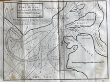
Rare 18thC Map America Plan of Port Royal Carolina Herman Moll 1739 Dublin
$257.18

1848 MEXICO - REPUBLIC OF TEXAS Map ORIGINAL Jeremiah Greenleaf (12X10)
$248.00

1890 Cape Cod & Martha’s Vineyard Old Colony Line Antique Map
$240.00

Pennsylvania 1796 Harris Doolittle rare American hand colored early state map
$210.00
$350.00
Bestseller
40% OFF

1879 VIEW of NANTASKET Beach - HULL - MASSACHUSETTS - Map ORIGINAL (25X15)
$189.00

1925 Kansas City Missouri Plat Map North Terrace Park 19.25"x20" RARE
$173.32

c1962 TEXAS OIL & GAS FIELDS Map MID CONTINENT Oil Gas Association ORIGINAL
$168.00

1925 Kansas City Missouri Atlas Plat Map RARE Color Lithograph Plate #198 & 199
$160.91

1925 Kansas City Missouri Atlas Plat Map RARE Color Lithograph Plate #194 & 195
$160.91

Antique Plat Map Leland Village Leelanau County Michigan 1907
$109.99

1861 Johnson’s New Illustrated (Steel Plate) Family Atlas. MISSING PLATES.
$99.95

Rare Antique Plat Map Salmon River Tract Southern Idaho c.1908 22 X 28.5
$95.00

State of Florida around 1853 Ensign miniature hand colored map nice patina
$58.80
$98.00
Bestseller
40% OFF

Boston city plan Massachusetts 1870 Johnson large hand colored map
$57.00
$95.00
Bestseller
40% OFF

Antique 1895 US Geological Atlas Pikeville Tennessee Folio Maps
$45.00

1903 Antique Kansas Map Fold-Out Color County Lines Railroads Indian Territory
$34.00

1891 ARIZONA MAP NEW MEXICO ANTIQUE FULL COLOR RAILROADS RIVERS MOUNTAINS RIO GR
$26.50

1891 COLORADO MAP UTAH ANTIQUE FULL COLOR RAILROADS MOUNTAINS GREAT SALT LAKE RV
$26.50

1862 Bacons Military Map of America Civil War Wall Map Poster - 24x36
$25.95

St. Simons Sound, Brunswick Harbor & Turtle River, GA - 2020 Nautical Chart
$24.95

1890s “Map of the Indian and Oklahoma Territories” Vintage State Map - 24x32
$24.95

1862 Military & Railroad Map US Civil War Era - 24x32
$24.95

Tampa Bay and St. Joseph Sound, FL - 2024 Nautical Chart Print | Coastal Nav,
$24.95

Fair Haven, NY - 1943 Topographic Map | Vintage USGS Print | Historic NY Map
$24.95

1830s Historic Map of The Republic of Texas by Stephen F Austin - 24x30
$23.95

1771 Early American 13 Colonies - East Coast Map - 24x28
$23.95

U.S. South Eastern Map 1857 Copper Plate Engraved
$21.95

Territory of Alaska 1936 Vintage Style Steamship Route Map - 20x30
$18.95

1700s New World Spanish Colonies Old Map - 20x28
$17.95

1732 Carolina Historic Old American Map - 20x28
$17.95
North America 1771 Colonial Map - 13 Colonies - 20x24
$16.95

1750s Detailed Map of New Spain and the Spanish Colonies - 20x24
$16.95

1680s Early Map of North America - New Mexico - English Empire - 20x24
$16.95

Map of Ohio 1857 Copper Plate Engraved
$16.95

1867 Arizona New Mexico Historic Old Map - 20x24
$16.95

Map of Crawford Notch, NH (White Mountain National Forest) 1946 Edition
$15.00

Map of the United States 1857 Copper Plate Engraved
$14.95

Prohibition End at last CHICAGO TRIBUNE Newspaper Headlines 12 x 18 Poster
$14.95

1933 Long Island NY Classic Pictorial Historic Map - 16x24
$13.95

1627 Map of Virginia by John Smith Historic Vintage Style Wall Map - 18x24
$13.95

1860s “Township Map of the State of Ohio” Vintage Style US Map - 16x20
$13.95

1930s Cape Cod Massachusetts Historic Early Map - 16x24
$13.95

1830s Historic Map of Texas Land Grants - 16x20
$13.95

1869 Leavenworth Kansas Vintage Old Panoramic City Map - 18x24
$13.95

Sasquatch Bigfoot Art Print Vintage Colorado State Map Wall Decor Bigfoot Gift
$9.95

FENTON HOLLY LINDEN AREAS MICHIGAN VINTAGE 1976 MAP
$4.00


